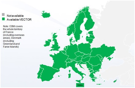
EuroBoundaryMap (EBM) is one of the products EuroGeographics AISBL Organization. This is the geo-database at the scale 1:100 000 covering 41 countries. It contains geometry, names and codes of administrative and statistical units continuously updated by our members, the national mapping and cadastral agencies (NMCAs) of Europe.
The EuroBoundaryMap published on the geoportal is the result of an agreement signed by the Head Office of Geodesy and Cartography and the EuroGeographics Association for the implementation of the database in question.
EuroBoundaryMap 2021 offers:
- Geometry of all European administrative and statistical units from the most detailed local level to country level.
- Names (Unicode-UTF8 and ASCII) and unique hierarchical structured codes (UIDs) of all administrative units on each national administrative level.
- Unified coding system for all the administrative levels including designations of different national levels and the relations between them.
- Links to statistical LAU- and NUTS codes for all local administrative units of EU27.
Detailed iformation about EuroBoundaryMap (EBM) is avaiable at:
https://eurogeographics.org/products-and-services/ebm/