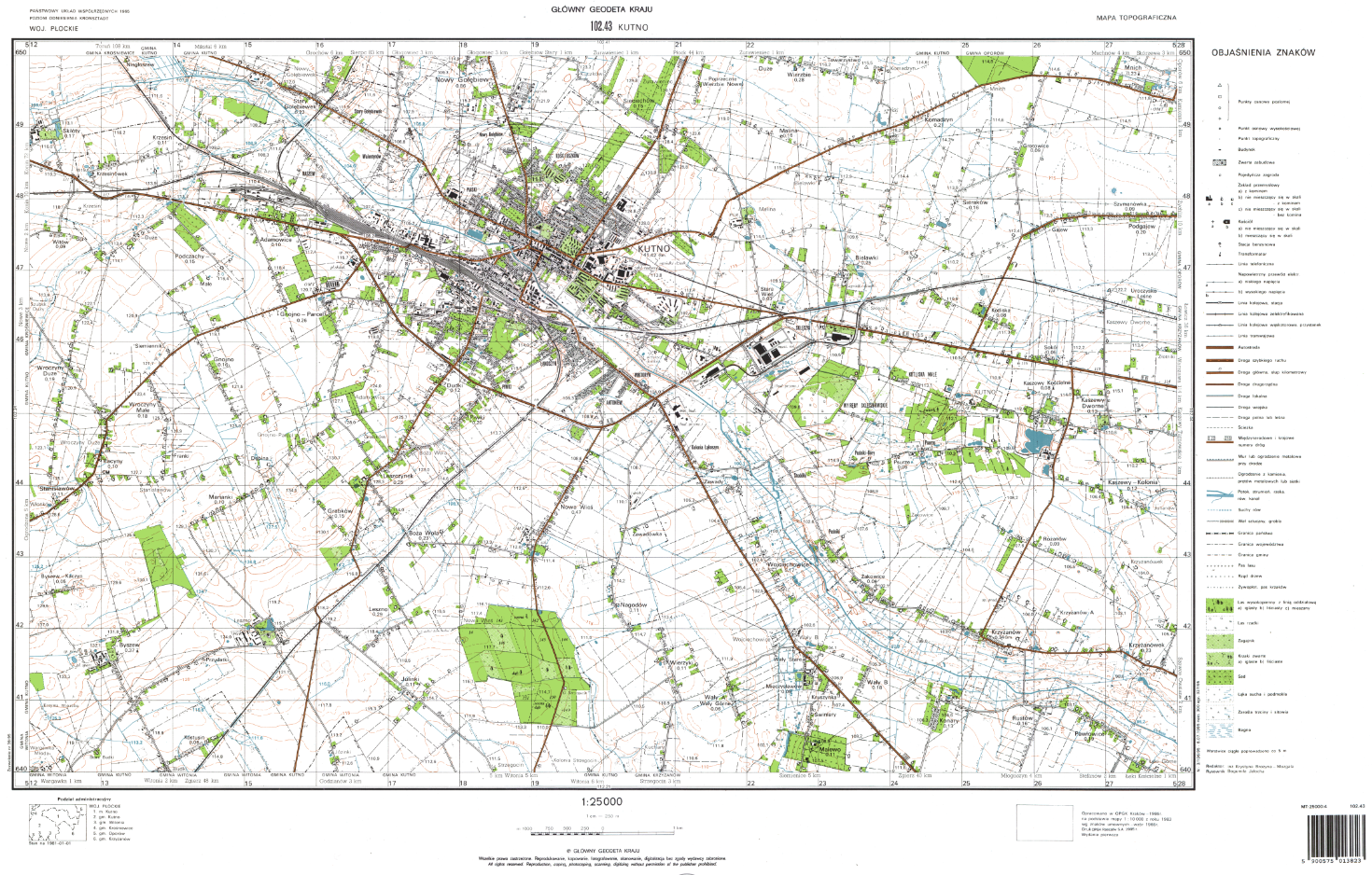
Mapy topograficzne
Mapa topograficzna jest opracowaniem kartograficznym w skalach od 1:10 000 do 1:100 000 o treści ogólnogeograficznej, ze szczególnym uwzględnieniem obiektów topograficznych. Standardy opracowania map topograficznych określa rozporządzenie Ministra Rozwoju, Pracy i Technologii w sprawie bazy danych obiektów topograficznych oraz bazy danych obiektów ogólnogeograficznych, a także standardowych opracowań kartograficznych. Mapy topograficzne przeznaczone są do zaspakajania różnorodnych potrzeb gospodarczych, a w szczególności: do wykonywania obliczeń geodezyjno-kartograficznych, sporządzania planów zagospodarowania przestrzennego i ich realizacji, rozwiązywania problemów naukowo-badawczych, studiów nad terenem i oceny specyfiki terenu, jako materiał podkładowy do opracowywania map tematycznych, do celów zarządzania kryzysowego, do celów wojskowych, w turystyce czy archeologii. Mapy topograficzne w sposób wiarygodny i z odpowiednią do skali szczegółowością odzwierciedlają stan terenu, jego typowe cechy i charakterystyczne właściwości. Obraz terenu przedstawiany jest za pomocą umownych znaków graficznych, zgodnie z zasadami redakcji map.
Mapy topograficzne dostępne w centralnej części państwowego zasobu geodezyjnego i kartograficznego (dalej „czgik”), zostały opracowane w oparciu o wcześniej obowiązujące przepisy, na podstawie pomiarów terenowych, metod fotogrametrycznych lub metod kombinowanych. Mapy te są dostępne w skalach 1:10 000, 1:25 000, 1:50 000 oraz 1:100 000 i wykonane w układach współrzędnych „1942”, „1965”, „1992” , „GUGiK 80” oraz „WGS-84”. Mapy topograficzne są udostępniane w postaci plików rastrowych (skanów map) w formacie tiff lub geotiff lub w postaci drukowanej.
Ponadto, w czgik zgromadzono ok. 3000 arkuszy numerycznej mapy topograficznej w wersji podstawowej (szkieletowej), opracowanych zgodnie z instrukcją „Zasady redakcji map topograficznych 1 : 10 000 wzory znaków” (rok 1999) i są one udostępniane w formacie dgn.
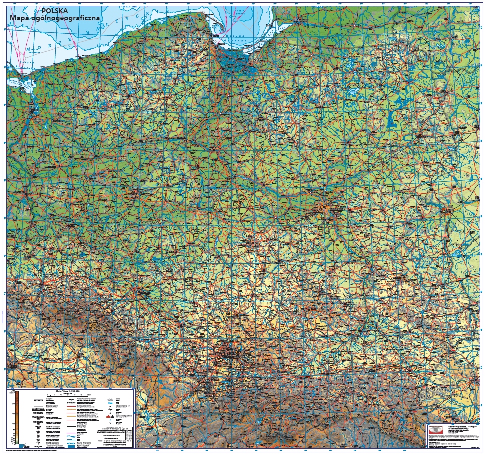
Mapy ogólnogeograficzne
Mapy ogólnogeograficzne opisują podstawowe obiekty i zjawiska geograficzne. Standardy opracowania map ogólnogeograficznych określa rozporządzenie Ministra Rozwoju, Pracy i Technologii w sprawie bazy danych obiektów topograficznych oraz bazy danych obiektów ogólnogeograficznych, a także standardowych opracowań kartograficznych.
Mapy ogólnogeograficzne dostępne w czgik to mapy przeglądowe w skali 1:250 000, 1:500 000, 1 000 000 i 1:4 000 000. Mapy ogólnogeograficzne powstały na podstawie bazy danych ogólnogeograficznych, w której zgromadzono dane ze szczegółowością odpowiadającą skali 1:250 000. Dane z tej bazy zostały poddane generalizacji i agregacji, co umożliwiło opracowanie baz danych o stopniach szczegółowości właściwych dla skal:1:500 000, 1:1 000 000 i 1:4 000 000, a następnie opracowanie map ogólnogeograficznych.
Mapy ogólnogeograficzne udostępniane są w postaci wektorowej w formacie PostScript (.eps) oraz w postaci rastrowej w formacie jpg i tiff. Bazy danych ogólnogeograficznych, na podstawie których opracowano te mapy, udostępniane są w formacie ArcInfo coverage.
W 2011 r., na zlecenie GUGiK, została opracowana mapa ogólnogeograficzna w skali 1:500 000 (Rysunek 2). Mapę opracowano w odwzorowaniu walcowym poprzecznym równokątnym Gaussa-Krugera z południkiem osiowym 19° długości geograficznej wschodniej i w układzie współrzędnych płaskich, prostokątnych „1992”. Postać cyfrowa mapy udostępniana jest w formacie wektorowym PostScript (.eps) oraz rastrowym PDF.
Mapy tematyczne
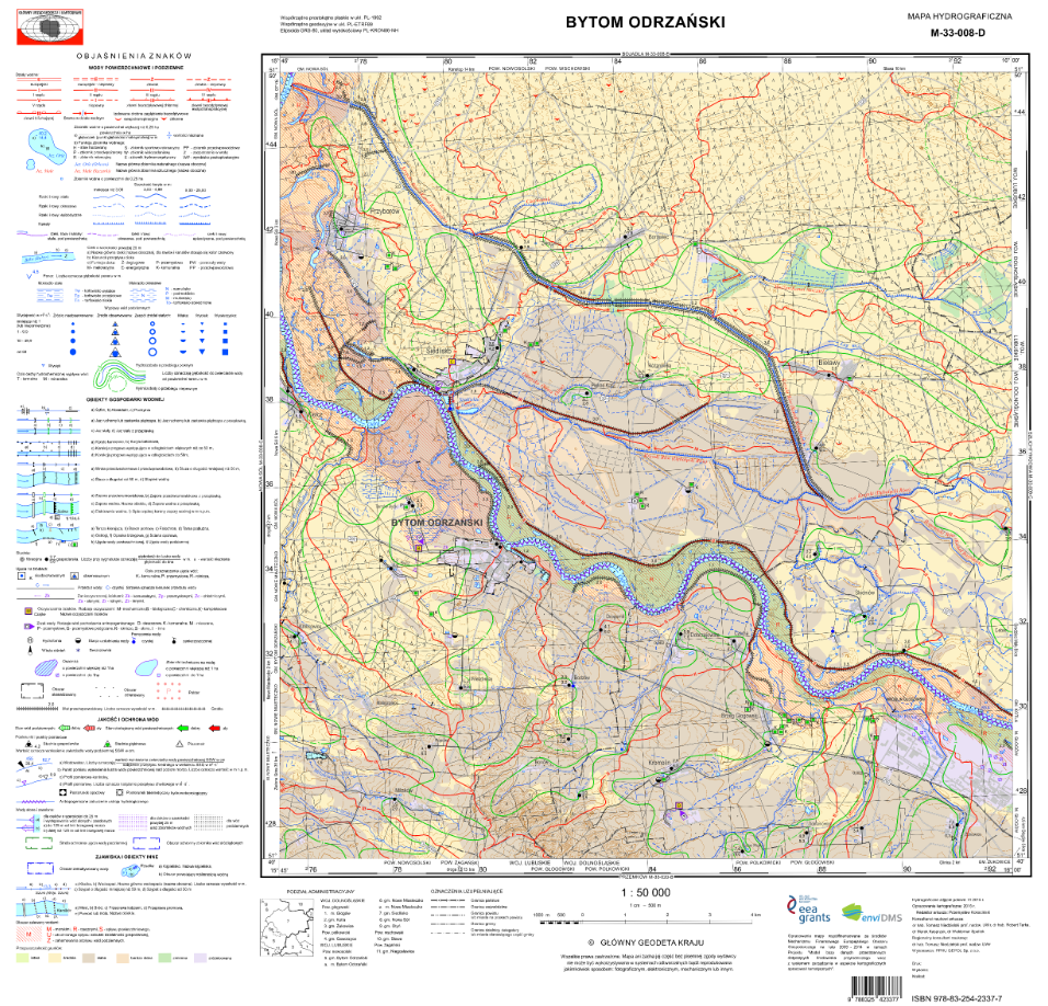
Mapa hydrograficzna Polski dostępna w czgik przedstawia chwilowy stan i warunki obiegu wody w okresie kartowania w powiązaniu ze środowiskiem geograficznym. Mapa ta została opracowana na podkładzie mapy topograficznej w skali 1:50 000 w układach współrzędnych płaskich prostokątnych „PL-1942”, „PL-1965” i „PL-1992”. Treść mapy uzupełniają komentarze umieszczone na odwrocie mapy. Komentarze do mapy hydrograficznej zawierają ogólną przyrodniczą charakterystykę obszaru przedstawionego na arkuszu oraz m.in.: charakterystykę opadów, wód powierzchniowych i wód podziemnych ze szczególnym uwzględnieniem ich zanieczyszczenia oraz przeobrażeń stosunków wodnych.
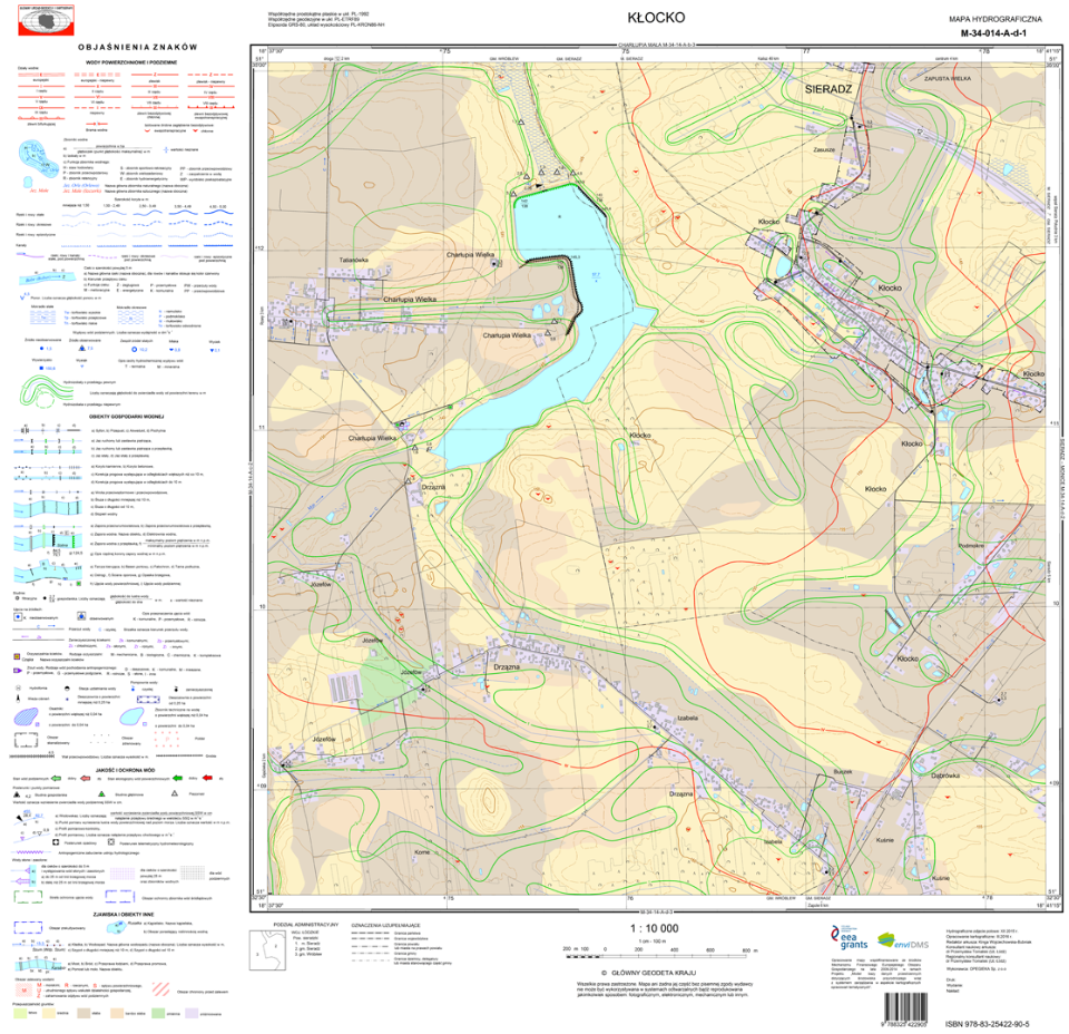
Mapy hydrograficzne zgromadzone w czgik dostępne są w formacie TAB z komentarzami dla układu „PL-1942” oraz w formacie TAB i shapefile (SHP) z komentarzami dla układu „PL-1992”. TAB jest formatem plików tworzonych przez program MapInfo.
W ramach projektu EnviDMS zostało opracowanych kilkadziesiąt arkuszy mapy hydrograficznej w skali 1:10 000 i kilkaset arkuszy w skali 1:50 000 w układzie „PL-1992”. Mapy te są udostępniane w formatach shapefile, mdb, gml – w zależności od arkusza.
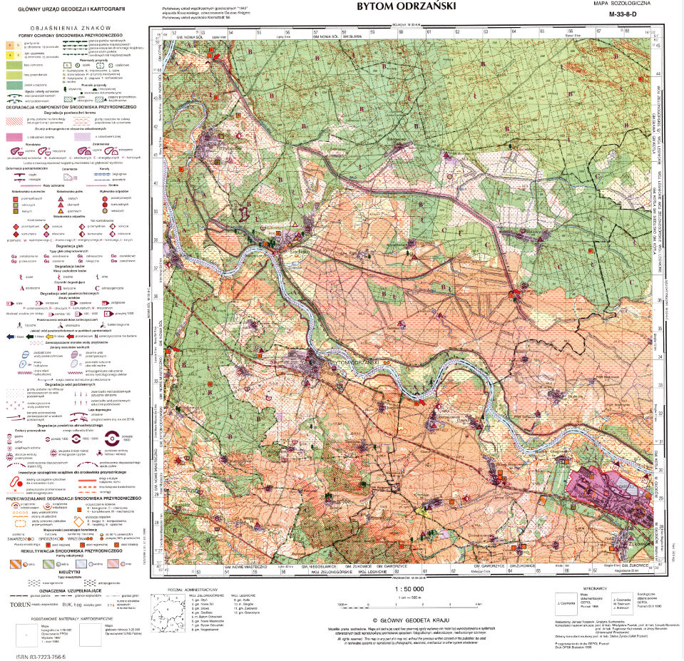
Mapa sozologiczna Polski to mapa przedstawiająca stan środowiska przyrodniczego oraz przyczyny i skutki przemian zachodzących w środowisku pod wpływem różnych procesów, a także przedstawiająca sposoby ochrony naturalnych wartości tego środowiska. Mapa ta została opracowana na podkładzie mapy topograficznej w skali 1:50 000 w układach współrzędnych płaskich prostokątnych „PL-1942” i „PL-1992”. Treść mapy uzupełniają komentarze umieszczone na odwrocie mapy. Komentarze dla mapy sozologicznej zawierają również m.in. informacje na temat zagrożeń i degradacji wód powierzchniowych i podziemnych, przedstawiona jest także ogólna ocena stanu środowiska i wskazania dotyczące jego kształtowania i ochrony. Mapy sozologiczne zgromadzone w czgik dostępne są w formacie TAB z komentarzami dla układu „PL-1942” oraz w formacie TAB i shapefile (SHP) z komentarzami dla układu„PL-1992”. TAB jest formatem plików tworzonych przez program MapInfo.
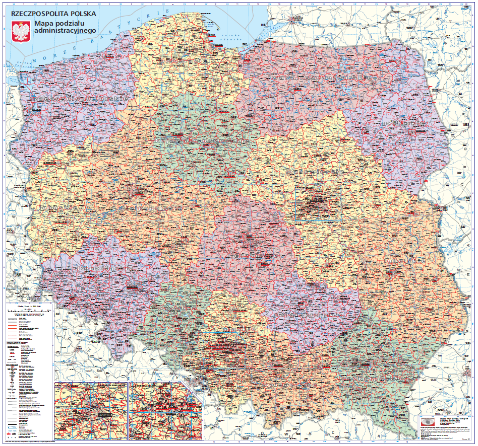
Mapa administracyjna Polski przedstawia granice administracyjne województw, powiatów i miast na prawach powiatów, granice gmin, granice miast w obrębie gmin oraz granice dzielnic Warszawy. Mapa została opracowana w układzie współrzędnych płaskich, prostokątnych „PL-1992” w skali 1:500 000 w odwzorowaniu walcowym poprzecznym równokątnym Gaussa-Krügera z południkiem osiowym 19° długości geograficznej wschodniej. Opracowanie aktualizowane jest rokrocznie w ramach prac własnych GUGiK’u i dostępne jako usługa przeglądania WMTS (adres na stronie www.geoportal.gov.pl).
Mapa krajobrazowa Polski przedstawia granice administracyjne, osadnictwo, sieć dróg, linie kolejowe, morskie trasy promowe, hydrografię, granice parków narodowych i krajobrazowych, cieniowanie, przełęcze, skały, jaskinie, porty lotnicze, porty morskie, węzły na autostradach i drogach krajowych dwujezdniowych, nazewnictwo, obszary leśne, puszcze, wyspy, półwyspy, przylądki, punkty wysokościowe, przejścia graniczne. Mapa została opracowana w układzie współrzędnych płaskich, prostokątnych „PL-1992” w skali 1:500 000, w odwzorowaniu walcowym poprzecznym równokątnym Gaussa-Krügera z południkiem osiowym 19° długości geograficznej wschodniej.
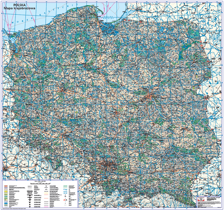
Mapy administracyjne i krajobrazowe są udostępnianie w formacie wektorowym PostScript (*.eps) oraz rastrowym PDF.
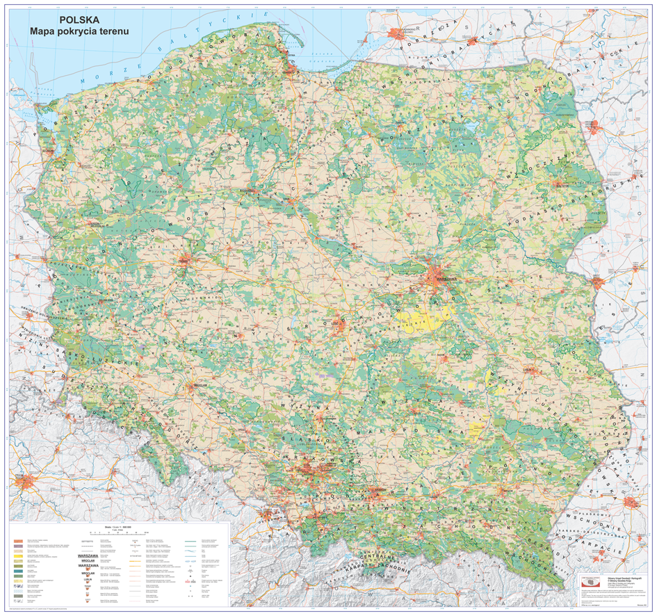
Mapa pokrycia terenu Polski przedstawia granice państwa, województw, morza terytorialnego), sieć osadniczą wraz z nazewnictwem, główne kategorie pokrycia terenu związane z fizycznym i biologicznym użytkowaniem powierzchni kraju, tj. tereny antropogeniczne, tereny rolne, lasy, obszary podmokłe, itd., sieć hydrograficzną, sieć szlaków drogowych i kolejowych, parki narodowe i krajobrazowe, wybrane punkty wysokościowe, przełęcze, jaskinie, skały, oraz rzeźbę terenu w oparciu numeryczny model terenu (metoda cieniowania). Mapa została opracowana w układzie współrzędnych płaskich prostokątnych PL-LCC na elipsoidzie odniesienia GRS80 według teorii stożkowego równokątnego odwzorowania Lamberta, z modyfikacją parametru – długość geodezyjna początku układu współrzędnych z 100 E na 190E. Mapa pokrycia terenu jest udostępniana w formacie geotiff i PDF. Opracowanie dostępne jest również jako usługa przeglądania WMTS (adres usługi w serwisie www.geoportal.gov.pl). Mapa aktualizowana jest co roku w ramach prac własnych Głównego Urzędu Geodezji i Kartografii.
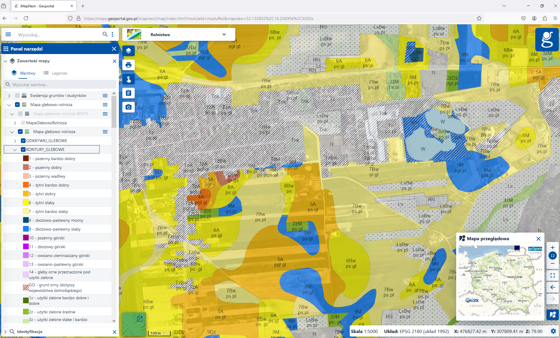
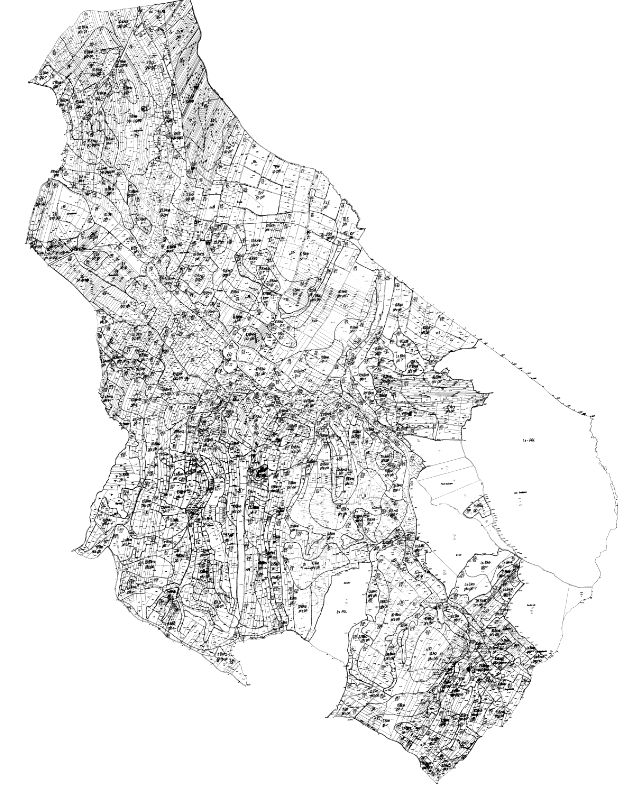
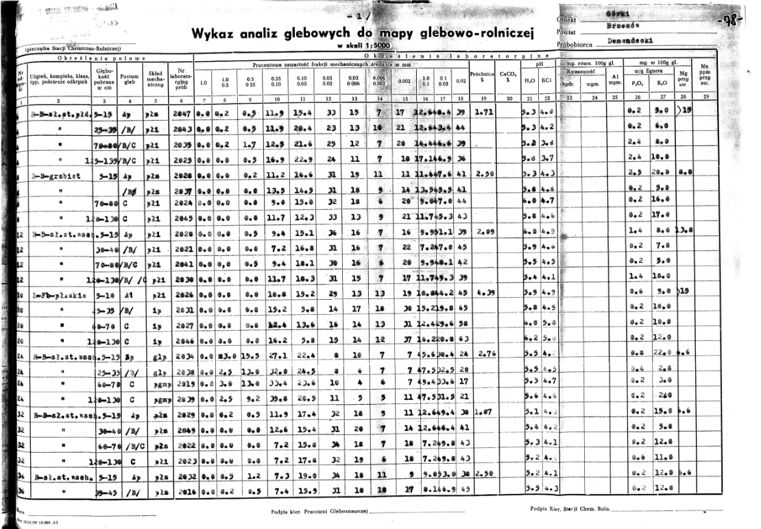
Mapa glebowo-rolnicza przedstawia przestrzenną zmienność siedliska glebowego oraz zawiera informacje dotyczące ważniejszych właściwości fizycznych i przydatności rolniczej gleby. Mapy glebowo-rolnicze dostępne w czgik, opracowane są w skali 1:5000 w formie wektorowej, w układzie PL – 1992 (EPSG: 2180) i obejmują obszary:
- województwa dolnośląskiego (dane GML opracowane na podstawie danych WODGiK oraz w ramach prac własnych GUGiK – uzupełnienie danych),
- województwa kujawsko-pomorskiego (dane GML opracowane na podstawie danych wektorowych z WODGiK i PODGiK oraz w ramach zleceń GUGiK),
- części województwa lubelskiego (dane GML opracowane na podstawie danych wektorowych z WODGiK i PODGiK oraz w ramach prac własnych i zleceń GUGiK),
- województwa lubuskiego (dane GML opracowane na podstawie danych wektorowych z WODGiK),
- województwa łódzkiego (dane GML opracowane na podstawie danych wektorowych z WODGiK),
- województwa małopolskiego (dane GML opracowane na podstawie danych wektorowych z WODGiK),
- województwa mazowieckiego (dane GML opracowane w ramach zleceń GUGiK),
- województwa opolskiego (dane GML opracowane w ramach zleceń GUGiK),
- województwa podkarpackiego (dane GML opracowane na podstawie danych wektorowych z WODGiK),
- województwa podlaskiego (dane GML opracowane na podstawie danych wektorowych z WODGiK),
- części województwa pomorskiego (dane GML opracowane na podstawie danych wektorowych z WODGiK oraz w ramach prac własnych GUGiK – uzupełnienie danych),
- województwa śląskiego (dane GML opracowane na podstawie danych wektorowych z WODGiK oraz w ramach zleceń GUGiK),
- województwa świętokrzyskiego (dane GML opracowane na podstawie danych wektorowych z WODGiK oraz w ramach zleceń GUGiK – uzupełnienie danych),
- województwa warmińsko-mazurskiego (dane GML opracowane na podstawie danych wektorowych z WODGiK oraz pozyskane od WODGiK),
- województwa wielkopolskiego (dane GML opracowane na podstawie danych wektorowych z WODGiK),
- województwa zachodniopomorskiego (dane GML opracowane na podstawie danych wektorowych z WODGiK oraz w ramach zleceń GUGiK – uzupełnienie danych)
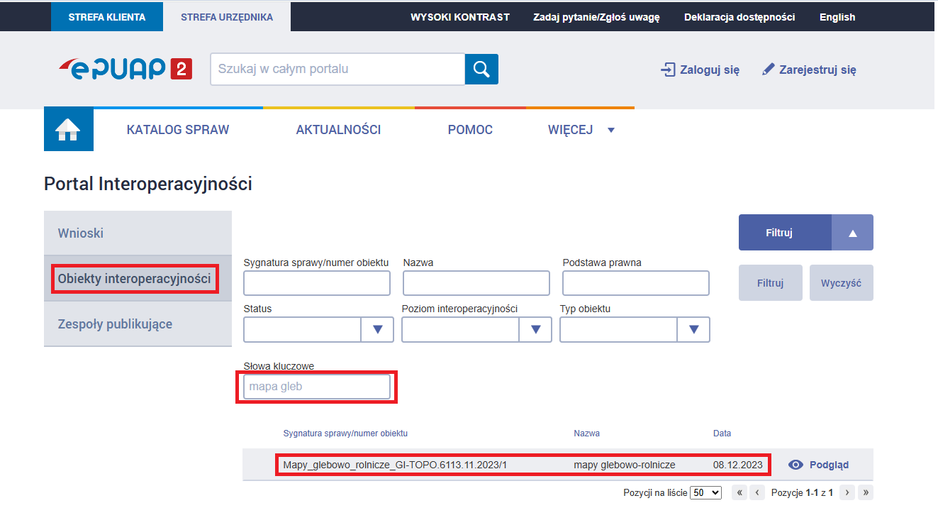
Materiały te udostępniane są w formacie GML zgodnym z najnowszym schematem aplikacyjnym dostępnym w portalu interoperacyjności https://epuap.gov.pl/wps/portal/strefa-urzednika/inne-systemy/pi.
Aby łatwo wyszukać schemat aplikacyjny po kliknięciu w powyższy link należy wybrać usługę „obiekty interoperacyjności” i w panelu filtruj wpisać Słowa kluczowe np. „mapa gleb”. Zostanie wyszukany dany schemat (sygnatura sprawy i data może być inna niż na poniższym rysunku w przypadku aktualizacji modelu).
Wektorowe mapy glebowo-rolnicze dostępne są również na potrzeby przeglądania w usługach:
• WMS (https://mapy.geoportal.gov.pl/wss/service/pub/guest/MapaGlebowoRolnicza/MapServer/WMSServer)
• WMTS (https://mapy.geoportal.gov.pl/wss/service/pub/guest/MapaGlebowoRolnicza/MapServer/WMTSServer).

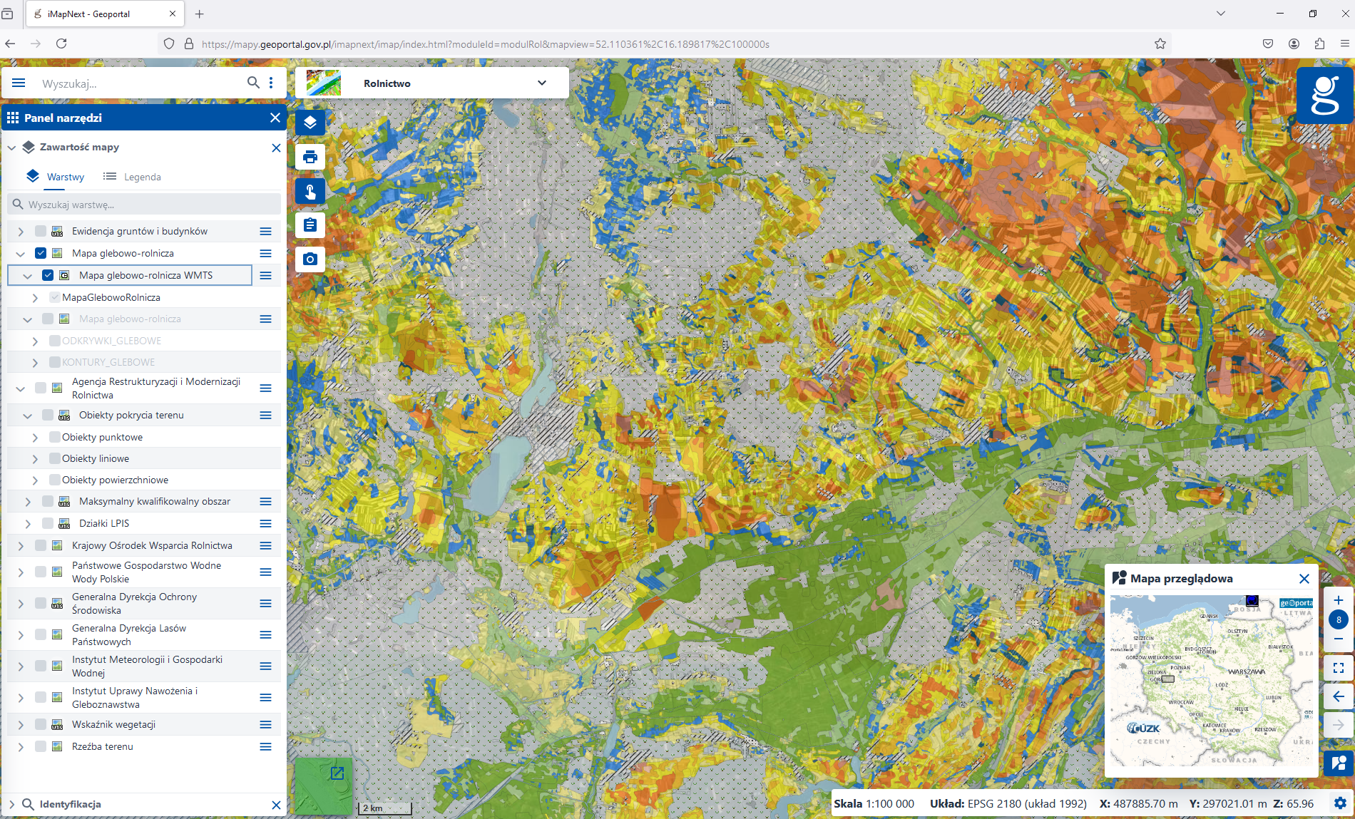
Ponadto w czgik dla części obszaru kraju dostępne są również formaty rastrowe (tif) udostępniane w postaci cyfrowej w formie skanów map (skalibrowanych w układach PL – 1992 lub PL – 2000, lub nieskalibrowanych). Dodatkowo dla niektórych województw dostępne są analizy glebowe w formacie tif lub xls.
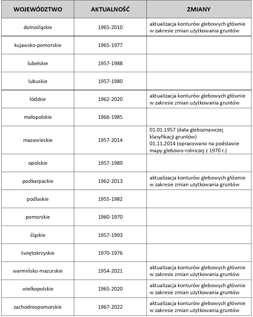
Aktualność danych wektorowych GML konturów i odkrywek glebowych w podziale na województwa
Poniższa tabela przedstawia zakres aktualności danych przestrzennych (GML) dotyczących konturów
i odkrywek glebowych w poszczególnych województwach
Mapa Geomorfologiczna Polski – jest opracowaniem kartograficznym przedstawiającym w skalach przeglądowych formy rzeźby i genezę powierzchni ziemi oraz informacje o zmianach jej uksztaltowania (zgodnie z rozporządzeniem rady ministrów w sprawie rodzajów kartograficznych opracowań tematycznych i specjalnych z 3 października 2011 r. – Dz. U. nr 222, poz. 1328 2011 r.).
W 2013 roku, dla wybranych obszarów Polski, zostały opracowane cyfrowe mapy geomorfologiczne w skalach 1:100 000 i 1:500 000 w układzie współrzędnych płaskich, prostokątnych „PL-1992”, w wersji polskiej i polsko-angielskiej.
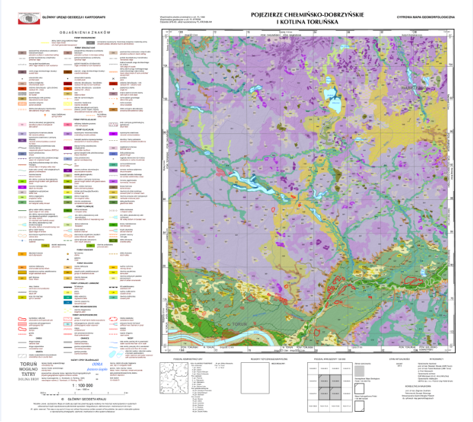
Treść tematyczna cyfrowej mapy geomorfologicznej Polski, w obu skalach, składa się z treści tematycznych oraz podkładowych. Treść tematyczną stanowią morfogenetyczne formy powierzchni ziemi i są to formy endogeniczne, denudacyjne, peryglacjalne, glacjalne, fluwialne, krasowe, eoliczne, litoralne i limniczne, organogeniczne oraz antropogeniczne.
Jako treść podkładowa zostały wykorzystane dane numerycznego modelu terenu, dane pochodzące z baz danych obiektów topograficznych, Państwowego Rejestru Granic oraz Państwowego Rejestru Nazw Geograficznych.
Mapy geomorfologiczne zgormadzone w centralnej części państwowego zasobu geodezyjnego i kartograficznego udostępniane są w postaci plików shp, gml (geometria z atrybutami), w postaci wektorowego obrazu kartograficznego w formacie lyr (dla każdego arkusza opracowany jest plik projektowy mxd z wizualizacja mapy) oraz w postaci rastrowej
w formatach tiff, jpg oraz pdf.
Mapy specjalne
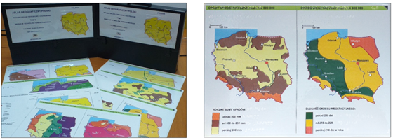
„Atlas geograficzny Polski” dla niewidomych i słabowidzących stanowi kompleksowe opracowanie tyflologiczne obejmujące zagadnienia ogólnogeograficzne i tematyczne z obszaru Polski.
Pierwsze wydanie (2004 r.) stanowi 25 plansz mapowych pogrupowanych w 3 bloki tematyczne:
- plansza podstawowa (granice kraju, wybrane miasta i rzeki);
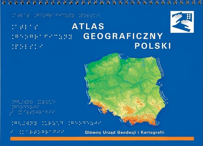
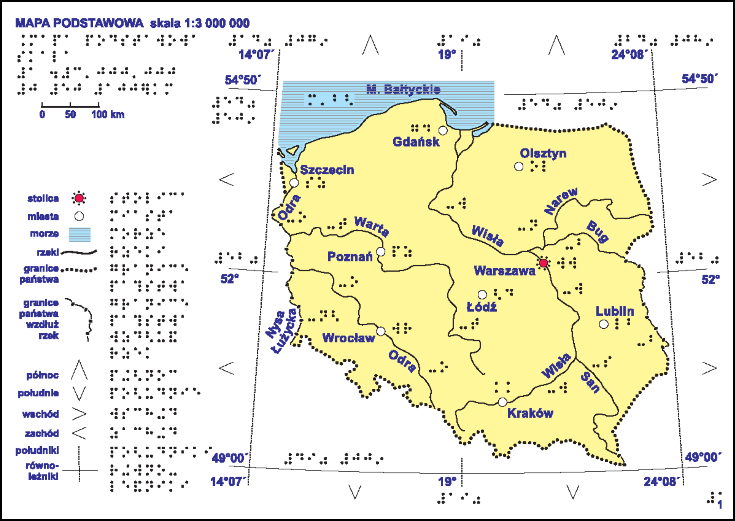
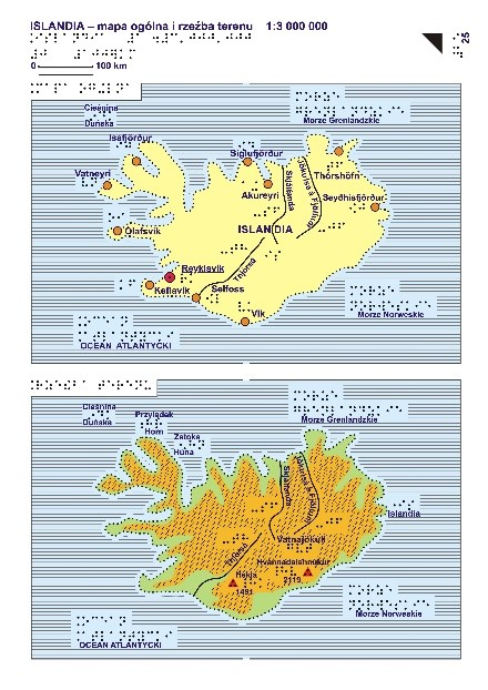
Rysunek 12,12a. Okładka oraz mapa podstawowa „Atlasu geograficznego Polski” dla niewidomych i słabowidzących
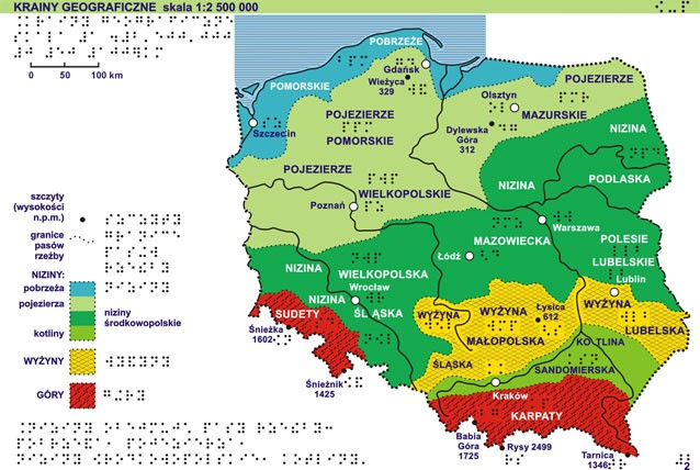
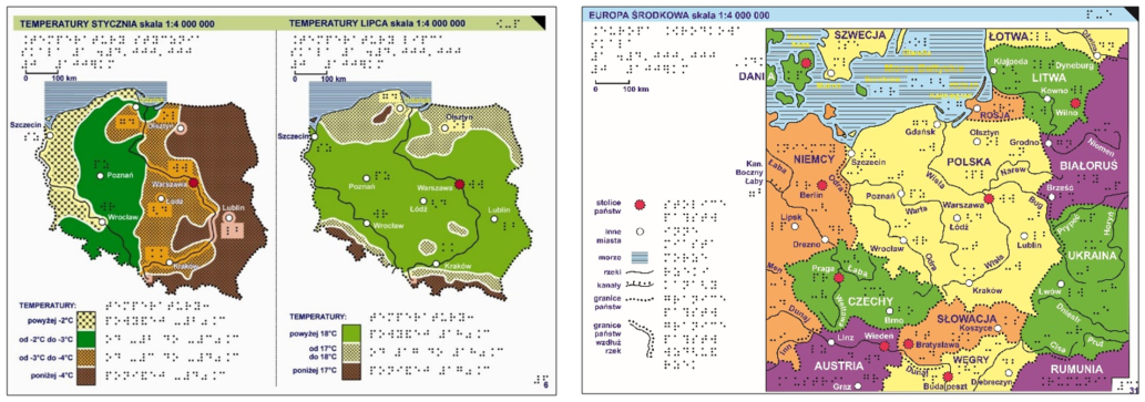
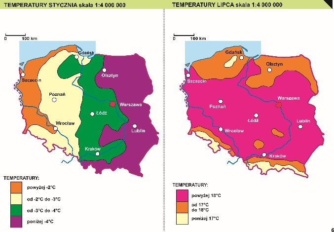
- dział I – ogólna charakterystyka środowiska przyrodniczego (7 plansz), obejmuje zagadnienia: krainy geograficzne, tektonika, utwory powierzchniowe, gleby, temperatury stycznia, temperatury lipca, opady atmosferyczne, okres wegetacyjny, wody, ochrona przyrody oraz degradacja środowiska;
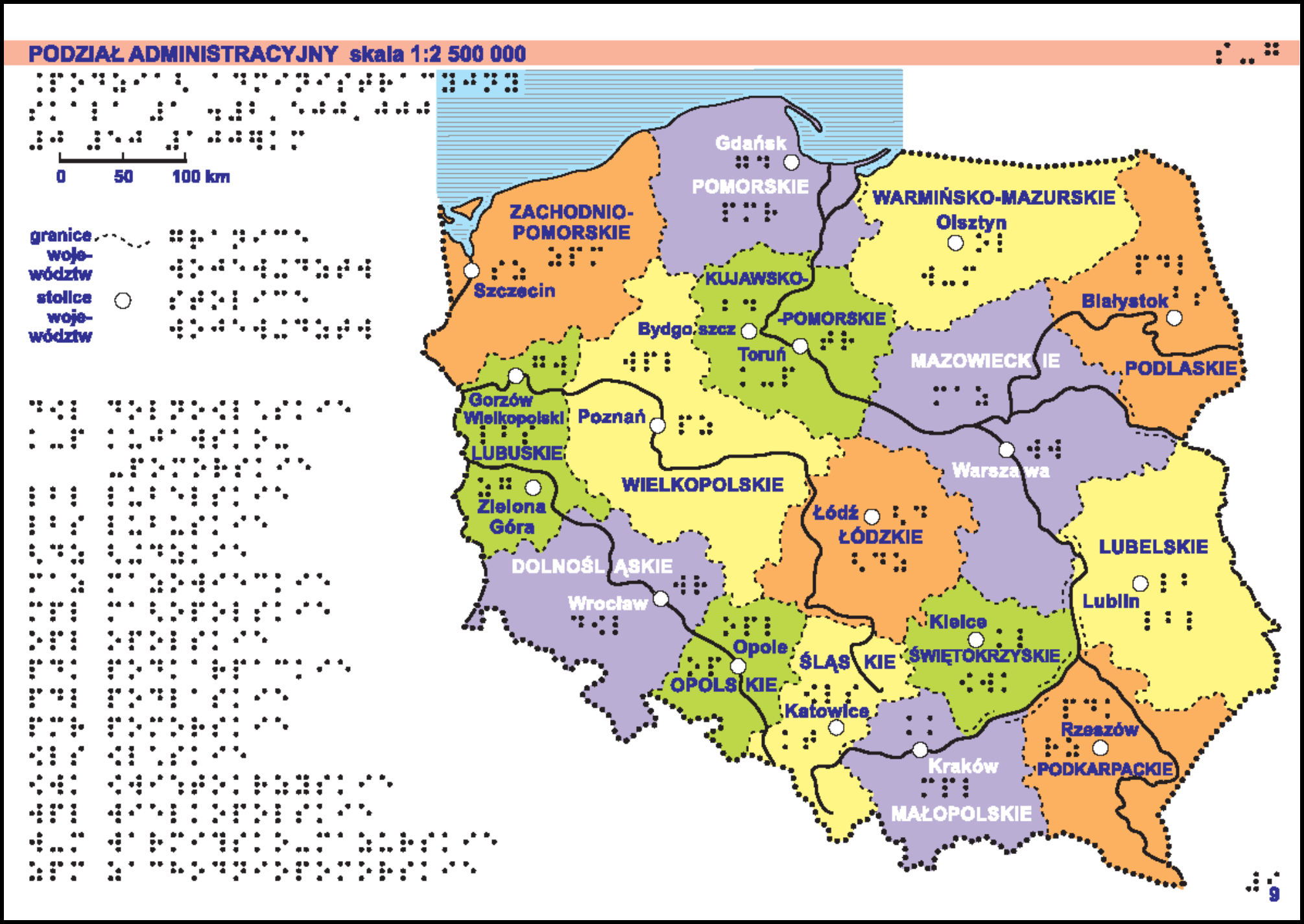
- dział II – zagadnienia społeczno-gospodarcze (13 plansz), obejmuje: podział administracyjny, miasta, gęstość zaludnienia, użytkowanie ziemi, rolnictwo, wydobycie surowców, elektrownie
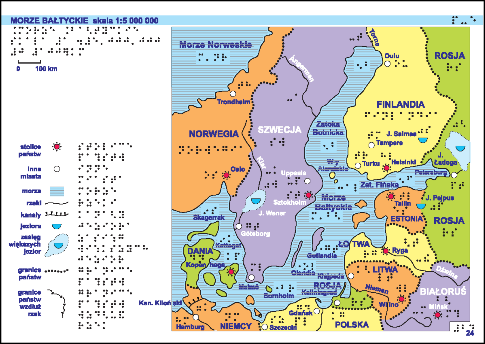
i rafinerie, huty metali, przemysł elektromaszynowy, przemysł chemiczny, przemysł włókienniczy, mineralny, spożywczy, drewno-papierniczy, ośrodki i okręgi przemysłowe, drogi, koleje i turystyka; - dział III – kraj w szerszym kontekście geograficznym i politycznym (4 plansze), obejmuje tematy: Europa Środkowa, Polska przed i po II wojnie światowej, Morze Bałtyckie, Unia Europejska.
Atlas został wykonany w technologii papieru puchnącego (zwanego mikrokapsułkowym, pęczniejącym, eksplozyjnym) – wydruk mapy w drukarce laserowej z zastosowaniem pełnej kolorystyki (elementy, które mają zostać uwypuklone muszą być wykonane w odpowiednich parametrach czerni lub odcieniach szarości) i uwypuklenie (pod wpływem wysokiej temperatury) warstwy reliefowej w termouwypuklarce.
Nowe wydanie (2020 r.) atlasu zawiera 34 mapy skompletowane w II tomach. Treść map atlasu obejmuje trzy grupy tematyczne: środowisko geograficzne Polski (11 plansz), zagadnienia społeczno-ekonomiczne (19 plansz), Polska w szerszym kontekście geograficznym i politycznym (4 plansze).
Atlas opracowany został w dwóch wersjach wydawniczych:
- cyfrowej – oddzielnie dla dwóch technologii druku i tłoczenia reliefowego: papieru puchnącego oraz termoformowania (Rysunek 13,13a i 14,14a),
- drukowanej (w technologii termoforowania) (Rysunek 15,15a).
Rysunek 15,15a. Przykład map w wersji do druku i wytłoczenia w technologii termoformowania
Pliki cyfrowe są udostępniane bezpłatnie zarówno w postaci wektorowej (pliki formatu CDR), jak i w postaci rastrowej (pliki formatu PDF, TIF oraz JPG).
„Plan Warszawy” dla niewidomych i słabowidzących – atlas (opracowany w technologii druku na papierze puchnącym), który tworzy 8 plansz:
I – Podział administracyjny (granice poszczególnych dzielnic, zasięg poszczególnych arkuszy planu miasta);
II – Komunikacja (drogi krajowe i wojewódzkie na terenie Warszawy, będące ważnymi szlakami komunikacyjnymi w obrębie miasta, kierunki, do których prowadzą: miejscowości leżące w obrębie aglomeracji warszawskiej oraz inne duże miasta na terenie kraju, najważniejsze dworce (kolejowe i autobusowe), lotnisko, linia metra);
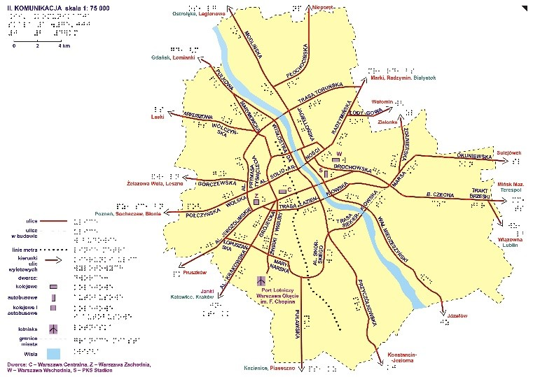
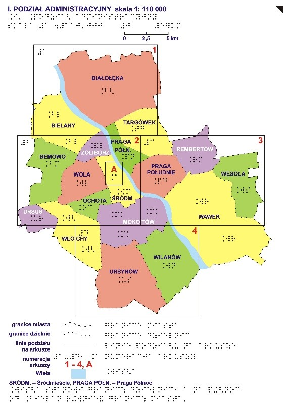
Rysunek 17,17a. Przykład map „Planu Warszawy” dla niewidomych i słabowidzących
III – Legenda;
V-VII – Plan Warszawy w skali 1:25 000;
VIII – Centrum – fragment arkusza z centrum miasta powiększony do skali 1:10 000.
„Atlas geograficzny Europy” dla niewidomych i słabowidzących – (opracowany w technologii druku na papierze puchnącym) składa się łącznie z 46 plansz formatu A3 pogrupowanych w trzy działy tematyczne.
Dział I przedstawia położenie kontynentu europejskiego na kuli ziemskiej (plansze: siatka kartograficzna, mapa świata oraz mapa Europy z fragmentami sąsiadujących z nią kontynentów).
Dział II przedstawia Europę w ujęciach tematycznych (map: ogólna kontynentu – z zaznaczoną linią brzegową, głównymi rzekami oraz siatką kartograficzną, ukształtowania terenu, hydrograficzna, podziału politycznego, osadnictwa).
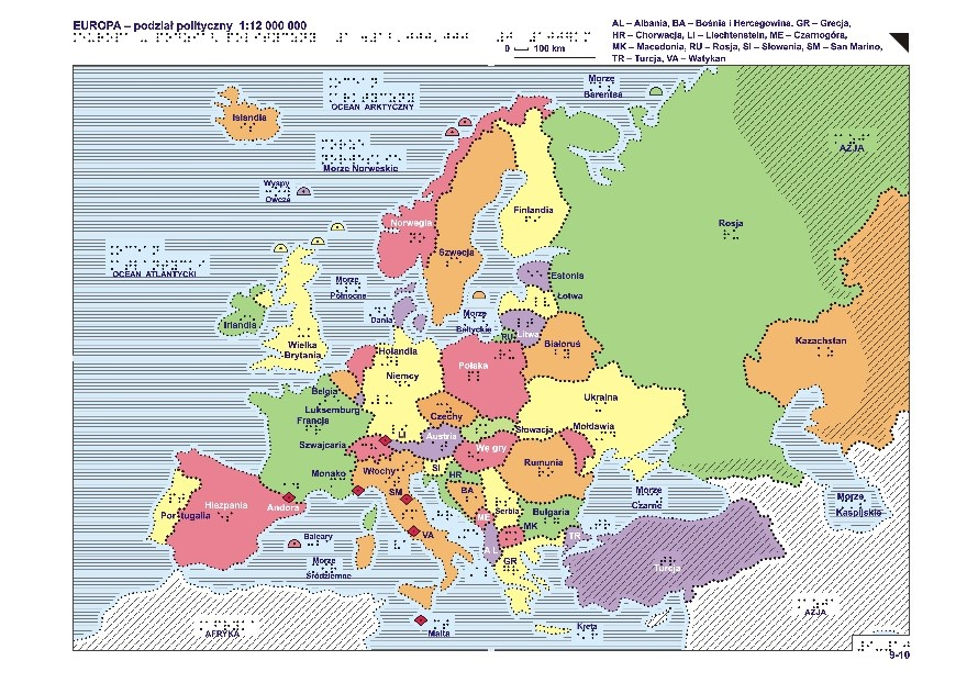
Rysunek 18,18a. Przykład map „Atlasu geograficznego Europy” dla niewidomych i słabowidzących
Dział III składa się z 35 plansz stanowiących przegląd 19 regionów Europy (większość jest pokazana na dwóch mapach: ogólnej, gdzie pokazane są rzeki, jeziora, główne miasta i krainy oraz rzeźby terenu, gdzie pokazane są obszary położone powyżej 200 m n.p.m., przebieg najważniejszych pasm górskich, najwyższe szczyty oraz elementy charakterystyczne dla geografii danego regionu, np. zespoły jezior, tereny bagienne czy urozmaicona linia brzegową).
„Atlas geograficzny świata” dla niewidomych i słabowidzących – ma postać luźnych plansz (formatu A3) przechowywanych w teczce. Atlas składa się 38 map podzielonych na dwie części tematyczne stanowiące tomy atlasu. Dodatkowo atlas opatrzony jest załącznikiem CD zawierającym opisy wszystkich map, metodykę ich czytania oraz inne informacje przydatne dla użytkowników.
Część pierwsza Atlasu jest poświęcona zagadnieniom przyrodniczym oraz społeczno-gospodarczym 1 plansz przedstawia problematykę społeczno-gospodarczą).
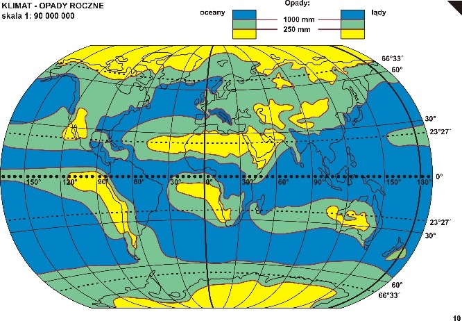
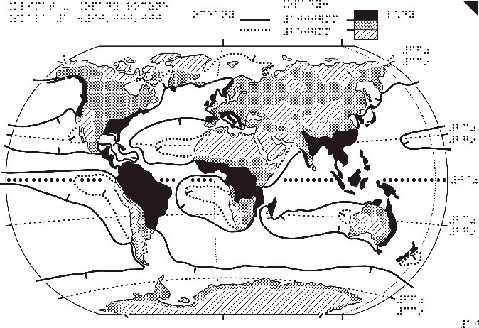
Rysunek 19,19a. Mapa Klimat – opady roczne z „Atlasu geograficznego świata” dla niewidomych i słabowidzących
Część druga to przegląd regionów – 15 map (w skalach od 1:10 000 000 do 1:40 000 000) przedstawiających rzeźbę terenu oraz podział polityczny kontynentów.
Dostępność usług przeglądania map
Mapy topograficzne, ogólnogeograficzne, tematyczne i specjalne (tyflologiczne) można przeglądać z wykorzystaniem usług WMS i WMTS, które standardowo podłączone są w serwisie www.geoportal.gov.pl. Usługi można także podłączyć w dowolnym oprogramowaniu, które potrafi takie standardy wykorzystywać (np. QGIS).
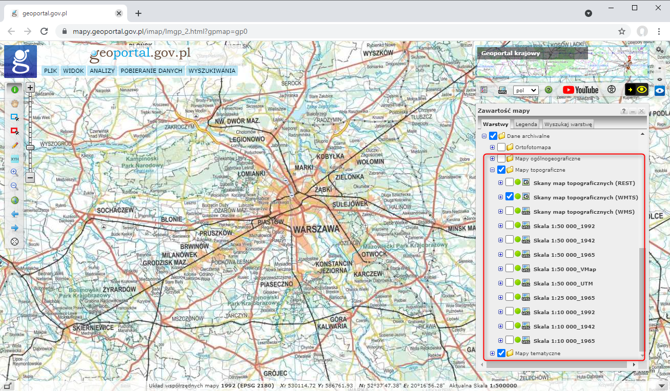
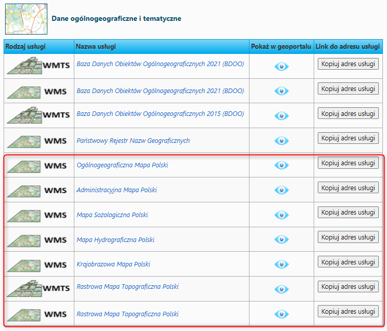
Informacje o wszystkich usługach prezentujących mapy topograficzne, ogólnogeograficzne, tematyczne i specjalne (tyflologiczne), prowadzonych przez Główny Urząd Geodezji i Kartografii można znaleźć w menu głównym serwisu www.geoportal.gov.pl w pozycji „Usługi/Usługi przeglądania WMS i WMTS” (Rysunek 20).
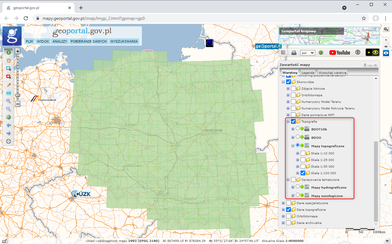
Szczegółowy zasięg dostępnych map topograficznych w danej skali i danym układzie można zweryfikować w serwisie https://www.geoportal.gov.pl/ w sekcji Skorowidze w grupie warstw Topografia -> Mapy topograficzne. Szczegółowy zasięg dostępnych map tematycznych można zweryfikować również w sekcji Skorowidze, w grupie warstw Opracowania tematyczne (Rysunek 21).
Udostępnianie map
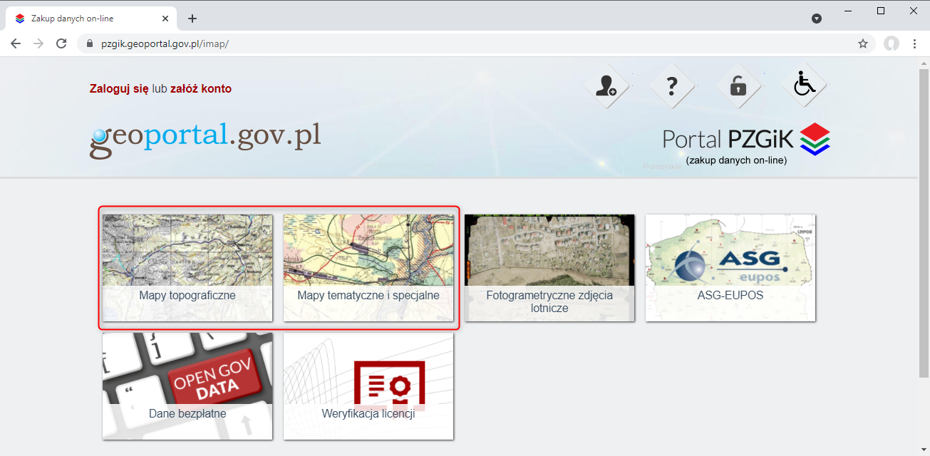
Udostępnianie map topograficznych, ogólnogeograficznych oraz tematycznych i specjalnych odbywa się na podstawie wniosku o udostępnienie materiałów państwowego zasobu geodezyjnego i kartograficznego lub poprzez PORTAL PZGiK
Mapy specjalne w postaci cyfrowej są dostępne bezpłatnie i możliwe do dowolnego wykorzystania. Pobieranie map specjalnych w postaci cyfrowej jest możliwe z serwisu www.geoportal.gov.pl, w którym w sekcji „Dane do pobrania” widoczna jest grupa warstwa „Topografia„, a tam z kolei warstwa „Opracowania tyflologiczne„. Po włączeniu wymienionej warstwy po kliknięciu w dowolnym obszarze Polski, będą dostępne do pobrania mapy tyflologiczne w formie cyfrowej (sitodruk, papier puchnący lub termoformowanie) (rys. 23).
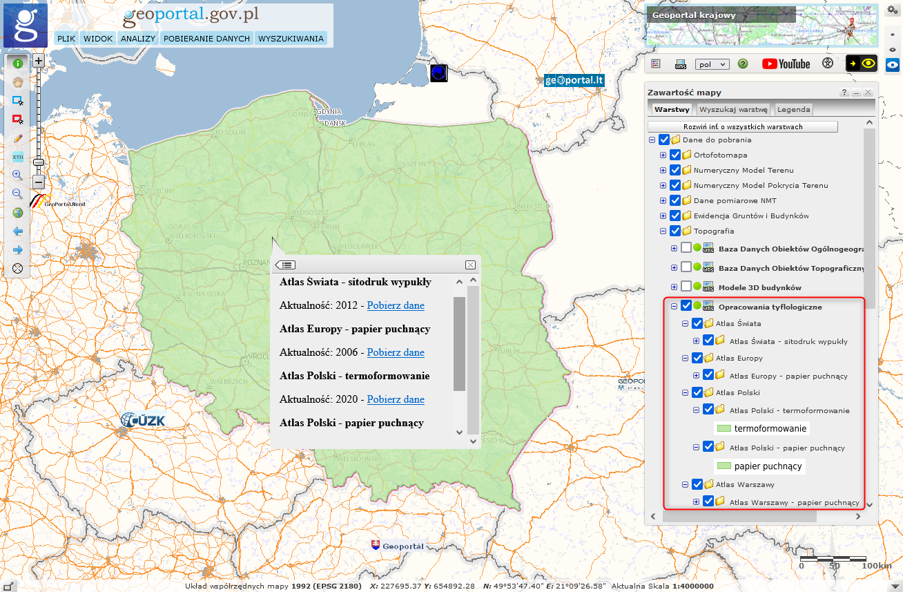
Pobieranie opracowań tyflologicznych w serwisie www.geoportal.gov.pl realizowane jest przez usługę WMS, a konkretnie przez jej funkcję GetFeatureInfo, która w miejscu kliknięcia, jako atrybut udostępnia link do pobrania odpowiedniego pliku mapy.